Connoisseur’s delight…door to freedom...
If you are not averse to any of these - - living at an average altitude of 4,250 metres in a cold desert;
- travelling on narrow (single lane), gravel and water filled roads winding through the Himalayas, which stare thousands of feet down into a violent river, and where road blocks due to landslides and snowfalls are as common as the day and night;
- living without newspaper and telecommunication network (save for BSNL) in a place unscathed by modernity;
then Spiti is the place for you - the connoisseur traveller, the solitude seeker, the adventurer!
Spiti Valley came on my radar a couple of years back while researching some exotic driving holidays in the Himalayas. I was instantly taken in. Ladakh had been on my travel list for over seven years (since the time the populace had not even heard about it), but seeing the swarm of casual tourists thronging to it since the release of 3 Idiots, I decided that it had to be Spiti that I must visit this time around, before the hotels over there too started dishing out thalis! Spiti, which means ‘the middle country’, is the land of ragged and snow capped mountains that reach out to the clear deep blue skies. Here, in the cold desert, trees are scarce and the moonscape expansive. Spiti is the land of several perennial rivers - Spiti, Pin, Chandra - whose gurgling sounds will soothe you in the night and whose ferocity will awe you when you travel alongside them in the day time. Ah, and not to mention the placid, azure blue lakes like Chandra Taal, Nako, Dhankar. The observer would also be struck by some of the most beautiful canyons and the most unusual clay and rock formations along the river bed and in the mountains. The continuity of the landscape is only broken by numerous waterfalls and glaciers, including one of world's largest non-polar glaciers - Bara Shigri. For the spiritual seeker, Spiti is home to some thousand year old Gompas (Buddhist Monasteries) and Tibetan art. There is also the mummy of a monk who meditated to death. It's a place which continuously resonates with the chants of Tibetan Buddhism (principal religion) and keeps you in a trance like state. The place also boasts of the world's highest motorable and inhabited villages. A place where lucky few can still find fossils in the valleys or manage to sight Snow Leopards, Ibex, Red Fox, etc. Finally, it is the beautiful people of Spiti who lend the valley its divine soul. These people, despite the harsh environment and poor living standards, are jovial and courteous. They live in match-box styled white coloured houses with lungtas fluttering from their rooftops and speak Bhoti and Hindi languages.
I discovered all of this and more during my seven day Trans Himalayan safari. Join me below on this journey through the middle land that is sure to leave an imprint on your mind and impel you too to embark on one… Located along the Indo-Tibetan border, the district of Lahaul & Spiti is the largest in the North Indian State of Himachal Pradesh. It has been a forbidden land for most part of its history. The land route from Manali is barely open for three-four months a year, while the route from the Capital city of Shimla (which is open year round) takes two days to reach Spiti Valley. For most part of the year the region is covered in snow. Temperatures in winter drop to as low as minus 30 - 35 degrees Celsius and rains are minimal. Consequently, the region is very sparsely populated; with some villages having only a handful of "souls" (that’s what the Government boards read over there. Population: 50 souls)! Unlike Ladakh, it has no airport and suffers from little documented history. It is precisely these factors that lend the place its mysticism and make the joy of discovering its unrivalled beauty indescribable.
For a slide show of complete set of pictures of Landscape & Monasteries, please click HERE. For a slide show of complete set of pictures of People & Culture, please click HERE. The Trans Himalayan odyssey begins…
Our safari was originally slated to start from Manali through the famed Rohtang Pass that serves as a gateway to the Lahaul & Spiti district. However, as luck would have it, owing to snowing in early June, both the Rohtang Pass and Kunzum La had been closed for vehicles. The day we reached Delhi (we were expecting the route to open in a day or two) we received news that some hapless people, who had been stranded in Spiti for 10 days, had to be airlifted, gulp! After some quick deliberations with Vishesh Shourie of ‘Incredible Spiti’ (an organisation that specialises in providing adventure solutions for Spiti - more about them later) we decided to change the itinerary. We would now enter Spiti via Kinnaur district by starting from Shimla and driving for two full days along the meandering Sutlej River to reach Tabo and finally exit through Manali. The two mountain passes would have “hopefully” opened by the time we were ready bid Spiti goodbye! While this upset the economics, the good part was that we would now get to see both ends of the valley. I begin below from the time we were introduced to our driver cum guide Dharamveer.
Day 1, Shimla – Narkanda – Reckong Peo - Kalpa: With barely four hours of sleep behind us in the beautiful city of Shimla (whose Wodehousian charm instantly transports one back to the days of the Raj), we were ready to embark on our journey. The Manager of the Royale Oaks Hotel (Lakkar bazaar) introduced us to our driver cum guide Dharamveer, a man of Nepali descent and medium built. The fact that he was also a Buddhist would prove to be invaluable on this trip.
The day was beautiful, skies clear, and a gentle breeze was wafting through the air carrying with it the sweet scent of pine trees. We purchased plenty of plums and other fruits from a roadside vendor (selling a cornucopia of fruits from local orchards) on the highway. They were dirt-cheap (compared to Mumbai), sweet and enough to last us for the next seven days. As we were driving along roads lined with apple orchards and soaking in the verdant pine filled vistas, the weather decided to get ominous. Dark clouds were hovering above us and threatening with their roar. The moment we got off the vehicle, to have lunch at a restaurant in Narkanda, the clouds screamed “bakra” (scapegoat) and opened their bellies upon us. Wind got chilly and gusty, light had faded and I started to worry about photography as Dharamveer promised stunning views ahead. He also told us that this would probably be the last place where we would get good Punjabi food. We ate to our heart’s fill and moved ahead.
We were now driving on the old Hindustan – Tibet road, traversing deep canyons, ridges, and some startling rock formations with the Sutlej River flowing in all its ferocious grandeur thousands of feet below. The landscape was barren. I have been to mountains before. But never before had I felt so vulnerable. The roads (NH 22) were extremely narrow and to call them roads would be a misnomer. They were merely paths or tracks for the most part. Roadblocks are as common here as day and night. Being summer time, we were treated to some gushing waterfalls in the Kinnaur district created by the melting snow and as the sun set, we passed the famed Nathpa – Jhakri hydel project, the Kharcham – Wangtoo hydel project and finally the Baspa hydel project (phew!) to enter Reckong Peo, the administrative headquarters of Kinnaur district. Located about 10 Kms from Reckong Peo is the quaint town of Kalpa (approx. 250 Kms from Shimla) where most motorists retire for the night. Hotel Apple Pie in Kalpa has some well appointed rooms that, the manager promised us, also offered the best views of the majestic Kinner Kailash (also called Kinnaur Kailash; 6,350 metres) mountain peak. The peak is revered equally by Buddhists and Hindus of the land. Day 2, Kalpa – Nako – Khab - Tabo: The best time, they say, for landscape photography is sunrise (and sunset) as the soft and gradually changing light weaves its magic upon the sky-scape. Unfortunately the sun rises at 5:15 AM in these parts! Waking up on the dot on a cold summer morning, I set aside the thick blanket and drew the curtains. What I saw left me awestruck. The Kinner Kailash was there right before me (well almost). The sun was rising from behind the mountains, giving their rims a nice golden glow. As the town was waking up, women went about their chores and we enjoyed our morning cuppa with eyes transfixed on the mountain peak. It seemed as if God had ordained timelessness upon this town. With no dark clouds around, the shutter release button was busy for most part of the journey. Even before it was noon we had encountered two road blocks thanks to some road widening work being undertaken by the Border Roads Organisation (BRO). In stretches where the BRO is active, the roads are excellent. Around noon we reached a place called Khab which marks the confluence of Spiti River and Sutlej River. The view was simply breathtaking. The point of confluence almost looked like the moment when two Sumo wrestlers collide! At this spot the road curves in to a steel bridge, built over the point of confluence, and leads onto a road built through a small semi-circular cut in the mountain (see picture). This is a spot worth spending a few minutes at to marvel at nature’s beauty and man’s zeal for conquest. From here onwards we gradually began to notice the changes in terrain. Rocky mountains gave way to brown and grey sloping mountains. The valleys were wider (enabling human settlement) and skies far more bluer. There was not a hint of green around, save for a few scattered farms cultivated by some enterprising people. Tufts of white clouds were strewn hither thither like pieces of cotton.
Around 1.00 PM our vehicle turned into Nako village, a hamlet known more for its lake. We had lunch at Lovon Hotel (by no means shady) and then sauntered toward the lake. I was momentarily dumbstruck by the serenity of the place. Not a leaf seemed to move. The clear reflection one could see in it of the surrounding environment told me how much the residents of this place cared about keeping the environment clean. Grudgingly we returned to our cars to resume our journey onward to Tabo. Beyond Nako lies the village of Sumdo, which formally announces your arrival in to Spiti Valley. On the way, Dharamveer pointed towards Kaurik peak from where a motorable road (now used largely by defence personnel) leads up to Indo-Tibet border and which used to serve as an important trade route in ancient times. Around 4.00 PM we reached Tabo (3,250 metres), which seemed like an oasis in this other wise arid land. With a population of 150 odd souls, Tabo is a quiet village that owes its popularity to the venerable Tabo Chos – khor monastery, which was founded in the year 996 AD! Driving past the monastery, we turned rightward on the helipad (which was built many years ago to receive His Holiness 14th Dalai Lama for the inauguration of the new monastery) and reached Tashi Khangsar Hotel, our abode in Tabo. The hotel was sandwiched between the monastery and a rocky mountain. Needless to say it afforded good views. Since the day was still good, we decided to tour the Tabo monastery after relaxing for a few minutes. The new monastery was closed in the evening so we spent most of our time exploring the old one. As we entered we saw a few young monks playing near the guest house and waving out to us. The vintage of the monastery becomes quite evident from its charming structures which are built from sand and mud. Set against blue skies and brown mountains, the precincts of the monastery have a uniquely magical feel. The inside of the monastery is a virtual treasure trove of millennium old murals, Thangka paintings, scriptures and sculptures. After marvelling at the work of art I realised why the Chos – khor monastery is also referred to as the ‘Ajanta of the Himalayas’. Unfortunately, photography is strictly prohibited inside the old monastery.
There is a German Bakery nearby which serves an assortment of pastries, cookies, breads and other delectable items. We decided to give it a miss and instead treated ourselves to vegetable Momos and Sea buckthorn tea at the hotel. Wah! For dinner we had Tibetan bread and butter.
Day 3, Tabo – Dhankar – Lahlung - Kaza: In the morning we first visited the new monastery. Dharamveer requested a senior monk to show us around and he willingly obliged. Grander than the old monastery, the place was a picture of calm. As we stood in silence, the monk gave us interesting pieces of information on the Buddhist religion, the works of art inside and of course The Dalai Lama – the single most revered person in the region. From here we proceeded toward the nearby caves (phukpas) for which we had to hike a bit from the main road. The rarefied air in Spiti Valley makes one breathless at the slightest of exertion. These caves are used by monks for meditation and one of them also has an elaborate mural inside. From here one gets a bird’s eye view of Tabo village and the surrounding scenery. Today’s first major destination was Dhankar (also spelled Dhangkar / Dangkhar; 3,900 metres). The Dhankar monastery, a near 1,000 year old symbol of Vajrayana Buddhist architecture, is one of the 100 most endangered monuments in the world (as recognised by the World Monuments Fund)! It is constructed on a 300 metre high ledge in a rocky mountain near the confluence of Pin and Spiti rivers. An architectural marvel of its time, today owing to its age and an earthquake that struck the region in 1975, it is in the imminent danger of collapsing. There is also a dilapidated fort (there are some wonderful murals inside its rooms), that once enveloped the entire complex, the remnants of which can be explored by hiking. As a matter of fact, it is this fort which lends the place its name. Dhankar literally means – fort on a cliff! Dhankar incidentally also has a lake, but for which one needs to hike for about an hour or two.

The entire complex, and the mountain on which it stands, has an almost fairy tale like beauty when viewed from a distance. From the monastery one can see some crazy natural rock / sand formations on the left, the Dhankar village scattered in the centre, and vast expanses of the valley on the right where the clean blue waters of Pin River merge into the muddy brown waters of Spiti River. The colourful Lungtas (prayer flags), strung from the poles, and swaying in the foreground add an air of spirituality to what is one of nature’s finest pieces of work.
At some distance away, on the opposite mountain, is the new Dhankar Monastery. Behind this new structure is a guest house where one can get a wide variety of food to eat. We decided to have our lunch here. Being in a Tibetan frame of mind we ordered Thukpa and fried rice for lunch. The gallery of the guest house is like a viewing deck overlooking the valley and a photographer’s paradise. I took several wide angle shots of the monastery and snow clad mountain peaks while waiting for the lunch to be served.
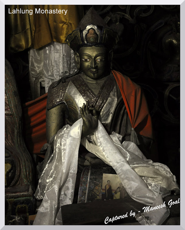
Motoring along the main road we took a diversion from Lingti village on a gravel road that supposedly would take us to Lahlung (also spelled Lalung / Lhalung). This journey, beside the Lingti valley, provides you with sights of some of the finest canyons and rock formations in India (some of which, atop the mountain, appear like the ramparts of a fort!). Half and hour into the drive we realised we were on the wrong path as we had reached a point beyond which it was impossible to drive. We turned back and returned to Lingti where some enquiries threw up an alternate road which finally did manage to take us to Lahlung.

Outside the monastery, as we began chatting with the monk and some rural folks (mostly giggling women), we realised that they couldn’t even place Mumbai and Kolkata on the map of India! Few had even heard of these places! Yet they were simple, charming and alluring people, gracious enough to invite us to join their tea party. Most of them work on the National Rural Employment Guarantee Act (NREGA) projects and knit sweaters during their free time. The old monk (no pun intended) treated us to fine lemon tea and ladoos. The lemon tea was far better than what one gets in an upmarket urban joint. It is also here that I met the dancing girl (see pictures). In reality she was not dancing, merely being shy and trying to cover her face as I tried to photograph her thereby creating the illusion. While parting the folks placed a violet coloured flower around our ears which they believe to be a good luck charm. I was truly overwhelmed by their hospitality.
In these parts I have realised, under the tutelage of Dharamveer, that a simple gesture like greeting juley (a kind of namastey in local dialect), with folded hands and slight bow, can help break the ice with locals.

From here we reached Kaza (3,660 metres), administrative headquarter of Spiti, which would be our abode for three nights. Kaza is the largest of all towns in Spiti (about 1,200 souls!) and has a bustling market place (selling everything - from items of daily need to curios for visitors like us – we purchased two Thangka paintings from here), bus-stand, petrol pump, hospital, and other facilities befitting a regional headquarter. Kaza also serves as the base for a number of mountaineers / trekkers who converge from all over the world to explore the Spiti Valley. In Kaza our home was Sakya Abode, the most popular hotel in the town (located next to the Kaza Monastery) – there is a beautiful array of white Stupas (Chortens) down the road from here. Tsering, the soft-spoken host of Sakya Abode, updated me on Chandra Taal lake, the route to which (a trek which begins from Kunzum La) had been closed for several days owing to heavy snowfall. The trip was getting unlikelier with each passing day as even efforts to clear the road were to no avail – glacial and mountain snow would slide and block the route again!

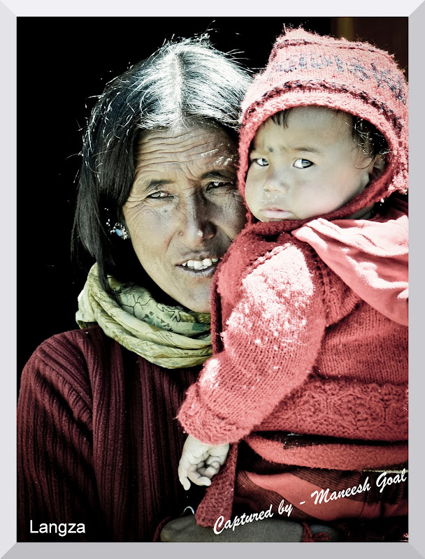
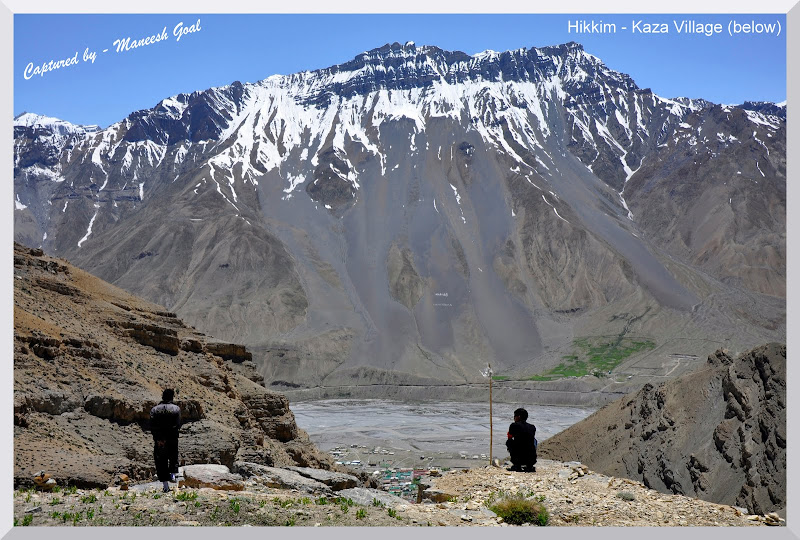
Day 4, Kaza – Langza – Hikkim – Komic – Kaza: I was eagerly looking forward to today as I have always wondered what life is like at great mountain heights. Our destinations for today were some of the highest inhabited and motorable villages in the world - all located at an altitude of 4,200 metres and more. Our first stop was Langza (4,200 – 4,400 metres, 148 souls), the fossil capital of India. Several aeons back when the Indian sub-continent arrived from the Southern Hemisphere (Gondwana) and collided with the Asian mainland, its impact led to the creation of the world’s highest mountain range, the Himalayas. A by-result of the impact was the fossilisation of several marine and other creatures at the seam. Langza is one such place which was witness to that event and as testimony has several fossils to show - scattered in the nearby nullahs and valleys. While many have now disappeared due to looting and illegal sales, the villagers assured me that a keen eye could find one even today in the various nullahs here and beyond. A drive towards Langza brings up a huge statue of Gautam Buddha (built at the edge of a hillock) on the horizon with the towering Chau Chau Kang Nilda peak (6,300 metres) in the backdrop. This statue and a 500 year old monastery are the principal attractions of Langza. There is also a fossil centre (Chadua) in Langza, which we unfortunately could not visit.


The Langza monastery was a quaint place where an old priest went about his prayers – reading scriptures and beating a drum simultaneously, unmindful of the visitors. We lighted two lamps after a brief chat with the priest and also took some pictures with his consent. He later offered us tea. There were a few farms scattered about the village, wherever a flat ground could be found, which were cultivated through ingenious ways of irrigation. These were the only sources of green to the eye. Dharamveer informed us that bulk of the farming is of Peas. He also told us that during the winters when temperatures dip as low as minus 30 degrees Celsius, the villagers largely prefer to stay indoors, living upon the supplies collected during the few months of summer. 

Day 5, Kaza – Kye – Kibber – Tashigang – Kaza: Today again we would be touring the highest villages of the world. After yesterday, our lungs were primed for it. Our first destination was the Kye Monastery (also spelled Ki / Kee / Key; 4,150 metres), which is the biggest monastery and Buddhist learning centre in Spiti Valley. The Kye monastery complex is a closely packed congregation of white houses built on a hillock overlooking the Spiti River. It is also known as Little Tibet.
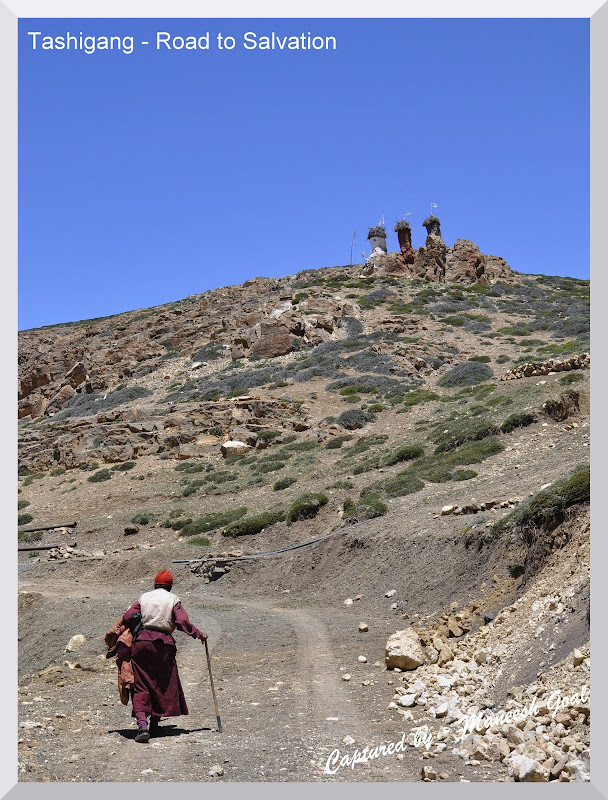
Inside the monastery, a monk showed us some 800 years old Thangka paintings, murals, musical instruments and several carefully preserved manuscripts – many of which were brought centuries ago from Tibet. Once here, people should also visit the upper floor / terrace of the monastery for a 360 degrees view of the valley and lungtas strung from ornately decorated pillars. In the prayer hall of new Gompa, four monks were engrossed in a prayer and we stood there for a few minutes observing their rituals. Their singing and music elevated us to a trance like state. I was shaken out of my trance by Dharamveer who prodded me to resume our journey towards Tashigang. It was only upon reaching the vehicle that I realised the reason for his impatience. Seated in the backseat was an octogenarian monk with a walking stick in one hand, beaded holy thread in the other and a slightly hunched back. He had not been to Tashigang for years and saw through us an opportunity to visit it now. He planned to stay there for a few days. Most monks travel to neighbouring monasteries on foot, trekking the Himalayas. However, his age obviously forbid him from doing so. Which also made me wonder how would he comeback since few vehicles ever visited Tashigang.
Tashigang is a remote village with about five - six homes and is known more for the La Darcha fair grounds. The monastery here is about a millennium old and housed in a small mud structure with thatched roof. The area around Tashigang also serves as pasture and breeding place for horses. Declining an offer for tea from the local folks, we motored ahead towards Kibber admiring the Chau Chau Kang Nilda peak, which is visible from here as well.
Kibber village was larger than all the villages we had seen in the last two days with about hundred houses. In the precincts of Kibber monastery I met a group of people from Maharashtra who had tried visiting Chandra Taal Lake. They informed me that the trail was packed with snow and that any attempt to walk would make the person slip and end up 10-15 feet away! Even though I knew during all these days that going to Chandra Taal would be a long shot, this bit of news killed the last vestiges of hope that were still embedded in my heart. Later in the night Tsering confirmed that Chandra Taal would not be possible and so we decided to visit the Pin Valley for our last sojourn. Day 6, Kaza – Kungri – Sagnam – Mudh – Kaza: As is said, what God taketh with one hand, He giveth (sometimes more) with the other! That in short is the sum and substance of Day 6. Little did we realise, when we woke up, that for the first time we would get to experience the true spirit and culture of the inhabitants of Spiti in all its splendour and finery!
Pin Valley is connected to Spiti Valley by a solitary bridge (Attargu) across Pin River. Most of the valley has been declared as the Pin Valley National Park, spread over an approximate area of 675 sq. Km. It is a natural habitat for endangered species like the Snow Leopard, Himalayan Ibex, Bharal, Red Fox, Snow Cock, Lammergeier, Woolly Hare, etc. Since the terrain is mountainous, tracking these creatures is only possible by exploring the vast expanses of the valley on foot with the aid of experts. I, however, managed to spot a scrambling Red Fox, a Lammergeier in flight and a few mountain goats on our way back in the evening. Our principal destination for the day was the ancient Kungri Gompa (also spelled Ghungri / Khungri; 3,520 metres). It is the main centre of Nyingmapa order of Vajrayana sect of Buddhism in Spiti and widely popular for the sword dance performances of Buzhens. Upon reaching the monastery we learnt that a two day cultural fair was on over there. Today, being the second day, the Lamas (monks) would be performing a number of Cham dances (also spelled Chham) for the dignitaries and residents of Pin Valley. Interspersed with these were folk dance performances by the students of the region and some comic acts by juvenile monks to lighten up the mood. We reached at about 10.00 AM, in the nick of time, as the proceedings were about to begin…
The Cham dance is a form of ancient Tibetan masked dance, which is performed in groups to the beat of traditional Tibetan instruments. It involves rhythmic circular movements, slow and minimal movements of the hand and feet, and periodic displays of energy when the Lama swirls 360 degrees in a flash by jumping in the air. While most dances appear the same (atleast to the layman), they vary in the design and type of various symbolic items used – masks, ornaments, costumes, head-gears, use of certain articles like daggers, Tibetan drums, etc. - each having its own meaning and interpretation. The dances are used to narrate different stories / incidents from the religious texts and to preach lessons. One cannot help but be awed by the sheer vibrancy of colours on display. These dances, while they appear simple, require lot of practice and co-ordination since the masks have no eye – holes!
The performances had the audience in gasps and raptures. This cultural affair provided me with plenty of opportunities to photograph the mood, the facets, the culture and colours of the people of Spiti in an atmosphere of candour and gaiety. The only regret was that we could not see the beautiful monastery from inside since it was closed on the occasion for visitors. The loss of Chandra Taal was squarely behind me.
As the event was drawing to a close, around 4.00 PM, we decided to checkout some of the other villages of Pin Valley such as Sagnam (the largest), Mikkim and Mudh (remotest). After spending some time admiring the scenery from Mudh and chatting with the locals (no tea this time) we returned back to Kaza. En route, we offered an Israeli trekker a ride in our vehicle. He was on a long visit to India exploring the Himalayan regions of Sikkim, Nepal, Varanasi, Rishikesh, Haridwar, Spiti and was soon headed for Ladakh. He was as much mesmerised by the place as we were.
Day 7, Kaza – Losar – Kunzum La – Batal – Chatru – Rohtang Pass – Manali:
The thing about Spiti is that it’s not over until it’s over. The drive from Kaza to Rohtang Pass is perhaps one of the most picturesque in India. Since we had to traverse some 200 odd Kms in a single day, we left Kaza at about 7.00 AM. The route is notorious for unexpected stoppages due to landslides / snow-slides as well as traffic jams at the Rohtang Pass. Hence, it was imperative that we reached Chatru by 4.00 PM.
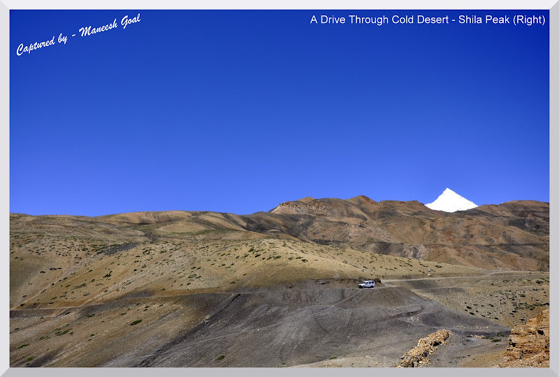
By 9:30 AM we were at the Losar check-post (also spelled Lossar; 4,079 metres). Most visitors prefer to use Losar as their base for the trek to Chandra Taal Lake, which begins from about 18 Kms from here. Natives here were discussing how the unexpected snowing and the resultant closure of the route had affected their business. As such the valley attracts tourists for mere three-four months and any loss of day can mean heavy losses for the tourism industry. In about an hour’s time we were driving through the Chandra Valley and as we neared Kunzum La (Kunzum Pass), we realised that we were now completely surrounded by snow – like a boat in the middle of an ocean. At about 4,590 metres, the area around Kunzum La is the highest in the region. The white clouds near the peaks of Chandra and Bhaga mountain ranges appeared like smoke billowing from chimneys. The Chandra River was now our companion (it goes on to meet Bhaga River near Tandi to form Chenab River) and the roads were lined with snow up to 10 feet high! From a distance we could see one of the world’s five largest non-Polar glaciers, the Bara Shigri Glacier – like white and grey lava flowing down a mountain.
At the Kunzum top there is a temple, which Chortens, dedicated to Goddess Kali. We spent about 15 minutes here – photographing the spectacular mountain peaks and the Bara Shigri Glacier. There were also quite a few herds of sheep and lamb grazing around the place on whatever little grass could be found. This entire region is a hotbed of small and large glaciers – Bara Shigri, Chhota Shigri, Kulti, Shipting, Pacha, Chandra, Ding Karmo, Gyephang, Bolunag, Shili, Shamundri, etc. It is believed that the Chandra Taal Lake was formed many years ago by the Bara Shigri Glacier due to geological disturbance in the region.
After praying at the temple for a safe journey we moved on toward Batal. Barely 30 minutes in to the drive and we encountered a serious roadblock. An earthmover was clearing mounds of snow that had slid on to the road. We decided to make the most of this opportunity and asked Dharamveer to click some clichéd pictures of us – playing in the snow against the backdrop of Bara Shigri Glacier.
The drive from here onward, though not steep, was very difficult. The roads, which would intermittently cross river beds, were full of small rocks and often streams of water from the melting snow would cross violently over them making it difficult for Dharamveer to navigate the vehicle over invisible rocks. Occasionally the wheel would get stuck. Other times the vehicle would simply bounce and swerve. Our anxiety was however alleviated by the sight of glacial ponds, frozen river beds and waterfalls. The dappled light falling on the valley and refracting in the air gave the sky an almost cosmic appearance.
Around 12.45 PM we reached Batal where we stopped to have tea. The chilling weather clearly warranted it. Batal is all of three – four dhabas (food joint) where most motorists, after a strenuous drive, relax to have lunch. Further, we reached Chatru (3,385 metres) around 3.00 PM where again we halted for some refreshments. The weather from here onward was similar to the one we encountered on the Shimla – Kalpa drive. Skies were overcast, it almost seemed like 7.00PM, and a light drizzle was on incessantly. The drive to Rohtang Pass was a slow, winding drive upwards. A climb made difficult by the heavy fog, which had reduced visibility down to a few feet. I would have my heart in my mouth every time Dharamveer would negotiate a turn, as neither the valley nor the bend in the road were visible. Dharamveer had to call upon all his experience, accumulated over 20 years of driving in these mountain passes, to reach us safely to Manali. Around 5.30 PM we were finally at the Rohtang Top. The place was crammed with innumerable shops that sell refreshments in the day time. A lot of tourists visit Rohtang Top to experience snow (mostly for the first time) and shamelessly leave behind a litter of plastic, a sight which I could not digest. Finally after an hour of descent we reached Manali and with it came to an end a journey which I can only describe as an odyssey. “At last they entered a world within a world – a valley of leagues where the high hills were fashioned of the mere rubble and refuse from off the knees of the mountains…. ‘Surely the Gods live here,’ said Kim, beaten down by the silence and the appalling sweep and dispersal of the cloud-shadows after rain. ‘This is no place for men!”
– Rudyard Kipling writes about Spiti in his book ‘Kim’.
The best time to visit Lahaul – Spiti is during the summer months of June – September. One could start either from Shimla or Manali depending upon his convenience and / or the mood of Rohtang Pass. Since one would be living at great heights, it is advisable that he consults his physician before embarking on the journey. As one may have realised from the travelogue, having the right vehicle and the right man at the helm of affairs is perhaps the most critical aspect of travelling to Spiti. It is hence my suggestion that you contact people who are absolutely trustworthy and are experienced in providing advice in the region. While it is possible to book a cab from the Manali taxi stand, you wouldn’t know beforehand about either the quality of the vehicle or the driver. I have always planned my own trips and done the bookings myself. But, as I researched about the place, I realised that this one trip had to be done differently. Having availed of their services, I would not hesitate one bit to recommend the guys at ‘Incredible Spiti’ – customised travel and adventure solutions provider for the Spiti region. The success of my trip owes a great deal to Vishesh Shourie and his team's meticulous planning, good selection of vehicle and hotels and a continuous drive to ensure that we had a great time. It was also wonderful to see how they handled a last minute change in itinerary owing to the closure of Kunzum La. Without them we would have been probably stuck.
You could give them the itinerary and budget and they will design a trip around it. Alternatively you could just book the vehicle and / or hotels through them or merely ask them for trip advice! Lastly, I would suggest that you keep your budgets flexible by at least 30 - 50% to meet contingencies like change of route, health problems, need to overstay owing to closure of roads, inclement weather, etc.
Copyright Maneesh Goal. All Rights Reserved. Write to me at mybioscope.blog@gmail.com


.JPG)